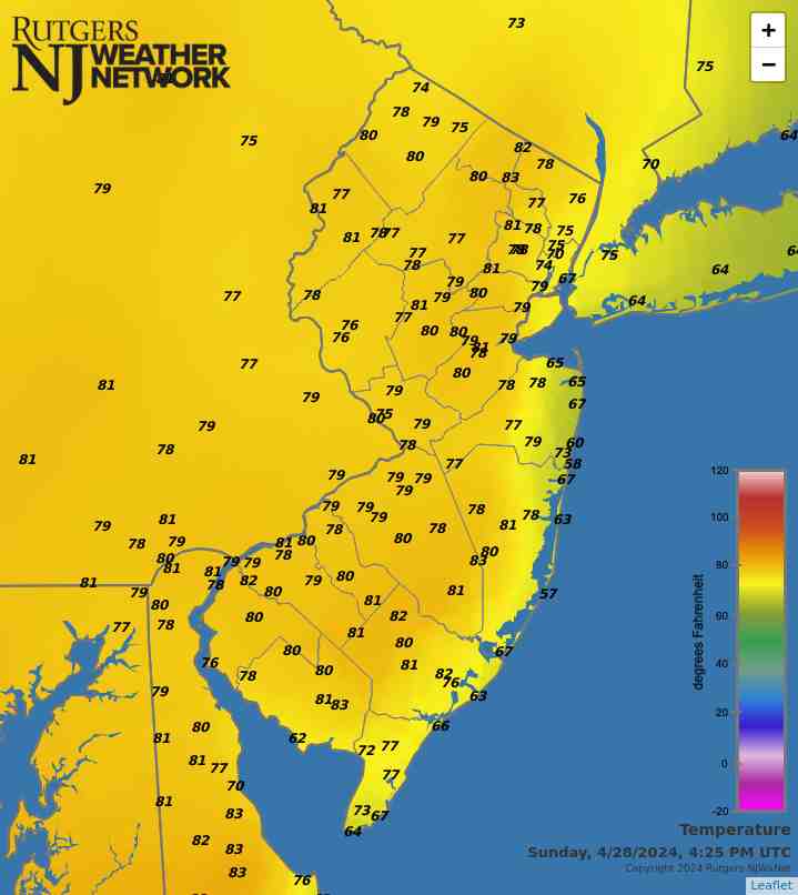
Latest Temperatures

Current Dew Point

Latest Wind Speeds

Wind Gusts

Top Story

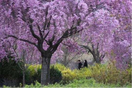
Cherry Blossom trees in full bloom at Branch Brook Park in Newark (Essex County) on April 10th. Photo by Tariq Zehawi/NorthJersey.com.

You would never have guessed it by looking at most days, with some wet, some dry, some warm, some cold, but put it all together and a rather normal April temperature- and precipitation-wise emerged from quite a variety of days and weeks. This is often the case during a transitional month (mid-fall or mid-spring), but this month took it to a bit of an extreme. Toss in a partial solar eclipse and an earthquake and it was quite the month for all who enjoy observing our fascinating world and solar system.

April precipitation averaged 4.14” across New Jersey. This is 0.44” above the 1991–2020 normal and ranks as the 42nd wettest of records dating back to 1895. Generally, the north received more rain than the south. The north climate division averaged 4.59” (+0.69”, 40th wettest), south division 3.89” (+0.31”, 48th wettest), and coastal division 3.65” (+0.10”, 61st wettest).

The year-to-date precipitation (rain and melted frozen precipitation) is 19.86”. This is 5.61” above normal and ranks as the 5th wettest January–April period on record. The top total is 22.98” in 1983 and the second through four wettest occurred in 1979, 1958, and 1953. The past 12 months have seen a state average 56.98” of precipitation, which is the 6th wettest of all such May–April periods dating back to 1895.

Latest Extremes

City, State Temp
Fortescue, NJ 60
Lower Alloways Creek, NJ 59
Atlantic City Marina, NJ 59
Dennis Twp., NJ 59
Little Egg Harbor Twp., NJ 58
City, State Temp
Sandyston, NJ 44
Hopewell Twp., NJ 44
Basking Ridge, NJ 45
Hackettstown, NJ 45
Pequest, NJ 46
most current information as of May 14 6:45 AM

Latest Conditions & Forecast

New Brunswick, NJ

Rutgers University Meteorology Program

48°F

Wind

1 mph from the NE

Wind Gust

1 mph from the NE

Patchy Fog then Slight Chance Showers
78 °F
Showers Likely
58 °F
Showers Likely
67 °F
Chance Rain
56 °F
Chance Rain
66 °F
Slight Chance Rain
55 °F
Mostly Cloudy
72 °F
Mostly Cloudy then Chance Showers
55 °F
Showers Likely
66 °F
Showers Likely
55 °F
Chance Showers
71 °F
Chance Showers
55 °F
Partly Sunny then Chance Showers
79 °F

Today

A slight chance of showers after 3pm. Patchy fog before 7am. Otherwise, partly sunny, with a high near 78. Southwest wind 5 to 10 mph. Chance of precipitation is 20%.

Tonight

Showers likely, mainly after 2am. Cloudy, with a low around 58. South wind 5 to 10 mph. Chance of precipitation is 70%. New precipitation amounts of less than a tenth of an inch possible.

Wednesday

Showers likely before 8am, then a chance of rain after 8am. Mostly cloudy, with a high near 67. East wind 5 to 10 mph. Chance of precipitation is 60%. New precipitation amounts between a tenth and quarter of an inch possible.

Wednesday Night

A chance of rain. Mostly cloudy, with a low around 56. East wind around 10 mph. Chance of precipitation is 50%. New precipitation amounts between a tenth and quarter of an inch possible.

Thursday

A chance of rain. Mostly cloudy, with a high near 66. Northeast wind around 15 mph. Chance of precipitation is 30%. New precipitation amounts of less than a tenth of an inch possible.

Thursday Night

A slight chance of rain. Mostly cloudy, with a low around 55. Chance of precipitation is 20%.

Friday

Mostly cloudy, with a high near 72.

Friday Night

A chance of showers after 2am. Mostly cloudy, with a low around 55. Chance of precipitation is 40%.

Saturday

Showers likely, mainly after 2pm. Mostly cloudy, with a high near 66. Chance of precipitation is 60%.

Saturday Night

Showers likely, mainly before 8pm. Mostly cloudy, with a low around 55. Chance of precipitation is 60%.

Sunday

A chance of showers. Partly sunny, with a high near 71. Chance of precipitation is 30%.

Sunday Night

A chance of showers. Mostly cloudy, with a low around 55. Chance of precipitation is 30%.

Monday

A chance of showers. Partly sunny, with a high near 79. Chance of precipitation is 30%.

Search by zipcode or city/state for the latest conditions, forecasts, graphs, maps and more nearest to you.

More News

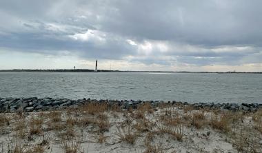
Looking south from Island Beach State Park toward Long Beach Island and the Barnegat Lighthouse on March 20th (photo by Dave Robinson).

So much for March flipping from lion to lamb or vice versa. March 2024 was often a lion throughout, with frequent roaring winds and multiple rain events producing a near-record monthly precipitation total and occasional flooding. The first half of the month ran at a record-warm pace, the monthly average later to be tempered by a second half that was cooler than the first. Still, the month emerged as the 9th mildest on record. Befitting the overall mild conditions, snowfall was scarce to non-existent. Winds gusted to 35 mph or higher at one or more Rutgers NJ Weather Network (NJWxNet)...

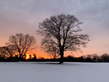
Sunset at Colonial Park in Franklin Township (Somerset County) on February 15th (photo by Dave Robinson).

Perhaps the title of this report is a bit overstated when it comes to February weather conditions, but not by all that much. However, like much of the coterminous United States, it applies rather appropriately to the December 2023–February 2024 winter. New Jersey’s winter conditions follow at the end of this report, with February discussed first. February 2024 was on the dry side. In fact, the statewide average precipitation (rain and melted snow) of 1.55” was 1.31” below the 1991–2020 normal and ranks as the 12th driest since records began in 1895. The northern climate division averaged...

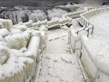
An ice-encased walkway and railings generated from spray from Great Falls (background) in Paterson (Passaic County) during the cold January outbreak (photo courtesy of Liz Reilly).

The first month of 2024 provided a potpourri of weather happenings, including excessive rainfall and flooding, multiple snowfalls, frequent strong winds, frigid days, occasional warmth, and culminating with persistent dismal (aka damp, cloudy) conditions. Something for anyone or perhaps not favored conditions for most people. Totaling up the multiple precipitation episodes, this month emerged as the 6th wettest January on record dating back to 1895. It was the wettest January in 25 years and follows this past December, which was the wettest on record. The statewide 6.39” of rain and melted...

More News

Gradual Seasonal Transition: November 2016 and Fall 2016 Recaps

December 8, 2016 - 1:51pm -- Dave Robinson

Snow photo

Much like the entire fall season, the transition into the cold half of the year was in no great hurry in November. Leaves dropped from ten days to two weeks later than normal, but eventually by the 28th the temperature fell to the freezing mark at West Cape May (Cape May County) and Newark Airport (Essex), these being the last locations in the state to experience their first freeze. A major exception to the slowly-transitioning pattern was the moderate high-elevation snowfall the weekend before Thanksgiving.

Drought conditions continued to be worrisome across the state, even spreading southwards. However, back-to-back heavy rainfall events on the 29th and 30th provided some replenishment to thirsty soils and began adding water to surface reservoirs across central and northern counties. It will be interesting to see if the atmospheric pattern change that delivered the late-month soakings is fleeting or will be longer lasting. Monthly precipitation (rain and melted snow) averaged 2.48” across NJ. This is 1.13” below the 1981–2010 average and is the 43rd driest November since 1895. It is worth noting that most of the National Weather Service stations that go into determining this average report in the morning. Thus the rain that fell later on the 30th is not factored into the monthly average; rather, it will be part of the December total. Snowfall averaged 0.4” for NJ but broken into regions amounted to 1.3” in the north, 0.1” central, and 0” south. The statewide total is average for Novembers between 1981–2010 but 0.7” below the 1894–present average.

A Climatological Potpourri: October 2016 Recap

November 9, 2016 - 2:21pm -- Dave Robinson

oradell reservoir

Season transitional months are often known for the wide swings in daily and weekly weather conditions. October 2016 did not disappoint when it came to exhibiting such variability. Moisture associated with a weakening hurricane to the south contributed to south Jersey’s heaviest rain event. A modest late-month storm brought the first frozen precipitation of the season to northern counties. Record warmth for so late in the season was part of a dry mid-month week. Halloween eve seeing the temperature touch 80° in some locations before a thunder-strewn frontal passage dropped temperatures to more seasonal temperatures for trick or treating.

Summer is Slow to End: September 2016 Recap

October 5, 2016 - 4:25pm -- Dave Robinson

Sunrise photo

Summer warmth continued into September, only beginning to relinquish its grip on the Garden State during the last week of the month. The average statewide monthly temperature of 70.1° was 4.3° above the 1981–2010 mean. This ranks as the 4th warmest September going back to 1895, with five of the eight warmest Septembers occurring since 2005. Seven of the most recent 13 months have ranked in the top 10 for warmth in their respective months.

Monthly rainfall averaged 3.36” across the state, which is 0.69” below average and ranks as the 61st driest of the past 122 Septembers. However, as discussed below, the average this month does not show the wide disparity of rainfall between the northern and southern parts of the state. While concerns for persistent dry conditions continued increasing across most of NJ through mid September, two soakings in the south alleviated worries in this region. Meanwhile, only one event of note produced totals exceeding an inch in much of the north, thus this region remains much too dry. As of the 27th, a good deal of north and central NJ was considered in moderate drought, with the remainder deemed abnormally dry according to the US Drought Monitor. North Jersey remained under a NJ Department of Environmental Protection “drought watch."

Top Ten August for Heat and Dryness, Yet Another Hot Summer in the 2000s: August and Summer 2016 Recaps

September 6, 2016 - 10:40pm -- Dave Robinson

Beach photo

While above-average temperatures persisted from July into August, the precipitation regime did a 180° reversal between months. A 9th warmest July transitioned to a 2nd warmest August across the Garden State, based on records extending back to 1895. The 14th wettest July proved to be a hydrological blessing following the 20th driest June and preceding the 9th driest August. While August ended with most of New Jersey designated as “abnormally dry” and the northeast in “moderate drought” according to the US Drought Monitor, and north Jersey remained under a NJ Department of Environmental Protection “drought watch,” water supplies would have been in far worse shape come late summer had July been dry.

A Return to Hot Julys After a Two-Year Respite; Awfully Wet Too: July 2016 Recap

August 3, 2016 - 5:01pm -- Dave Robinson

Flooding photo

The second half of the 2016 NJ weather and climate year began with plenty to talk about. Maximum temperatures were 90° or higher somewhere in the state on 20 afternoons. This, along with many warm nights, helped boost the mean monthly temperature into the top 10, based on statewide records back to 1895. Yet, remarkably, this was only NJ’s 5th warmest July in the past 11 years. The 77.2° mean was 2.2° above the 1981–2010 average.

On 15 July days an inch or more of rain fell somewhere in NJ. This included eight days with greater than 2” in spots and four days where a few locations exceeded 4”. Statewide, the average rainfall was 6.85”. This was 2.33” above average and ranks as the 14th wettest July since 1895. It was the wettest July since 2004, and the 4th wettest in the past 41 years. The northern half of the state (Mercer/Somerset/Union northward) averaged 7.27” (+2.49”, 14th wettest), while the southern region averaged 6.77” (+2.38”, 12th wettest). This all came in a month where the northern half of the state remained classified as being in moderate drought (D1) on the US Drought Monitor, with about half of south Jersey considered abnormally dry (D0). Also, on July 26th the NJ Department of Environmental Protection placed the northern half of the state in a drought watch. These actions were the result of notable rainfall deficits dating back to the early spring, with the warmth of the month exasperating low soil moisture, stream flow, ground water, and reservoir conditions. Clearly, the late-month heavy rainfall in a good portion of the state warrants a re-evaluation of drought status as NJ heads into August.

Rather Dry, but Still Some Storms: June 2016 Recap

July 6, 2016 - 1:58pm -- Dave Robinson

Tipped helicopter

Despite some damaging storms impacting portions of New Jersey on several days and some localized deluges near month’s end, June rainfall came in well below average. The statewide average of 2.36” was 1.66” below the 1981–2010 average. This ranks as the 20th driest June since 1895. Northern and central counties were generally drier than those to the south. At month’s end, the counties from Hunterdon, Somerset, and northern Middlesex northward were classified as being in “moderate drought,” the D1 category on the US Drought Monitor. The counties to the south, through Ocean and Burlington, were in the Monitor’s “abnormally dry” D0 category. June stream flow, ground water, and precipitation levels were all well below average, while reservoir capacities in the north began to dip below average near the end of the month.

Temperatures began on the cool side, but the second half of the month was warm enough to bring the statewide average June temperature to 70.6°, which was 0.5° above average. This ranks as the 30th mildest June on record. There was one minimal heat wave at some inland lower-elevation locations, where temperatures climbed to 90° or higher from the 19th–22nd. However, no location exceeded 93° this month. The dry conditions helped to rid the atmosphere of the previous day’s warmth during the nighttime hours, thus temperatures of 45° or lower were observed in spots on seven mornings.

A Tale of Multiple Seasons Within a Month and an Almost Backward Spring: May and Spring 2016 Recaps

June 7, 2016 - 4:54pm -- Dave Robinson

May 15 graupel photo

May had many weather faces. Cool, damp weeks to start things off, a blustery mid-month day with some frozen precipitation, a week of summer heat, and an early Memorial Day deluge up the New Jersey Turnpike corridor. When all was summed and averaged, the mean monthly statewide temperature came in at 60.0°. This was 0.8° below normal and ranked as the 55th coolest of the past 122 Mays. Precipitation averaged 5.01”, which is 1.01” above average and 23rd wettest.

Rain fell on a number of May days across NJ, keeping vegetation green and fire danger down. It was most plentiful in the southern half of the state, where Mount Laurel Township (Burlington County) totaled 7.74”. This was followed by Mount Ephraim (Camden) with 7.68”, Washington Township (Gloucester) 7.54”, Salem (Salem) 7.41”, Cinnaminson (Burlington) 7.02”, and Estell Manor (Atlantic) and Merchantville (Camden) each with 7.00”. The northwest corner had the least rainfall in May, with just 3.01” in Andover (Sussex) and North Arlington (Bergen), along with Mount Olive (Morris) at 3.04”, Hackettstown (Warren) 3.05”, and Franklin (Sussex) and Wantage (Sussex) each with 3.06”.

Another Dry Spring Month: April 2016 Recap

May 9, 2016 - 11:18am -- Dave Robinson

Brush fire photo

April continued a dry period that began in March. Monthly rain and melted snow totaled 2.34”. This was 1.72” below the 1981–2010 normal and ranks as the 20th driest April since 1895. The 4.35” March–April total was 3.94” below average and ranks as the 7th driest such interval. Unlike the abnormal warmth of March, the average April temperature of 50.7° was 0.5° below normal. This ranks as the 48th mildest on record.

Statewide snowfall averaged 0.2”, which is 0.7” below the 1981–2010 mean. The southern counties averaged 0.3” (-0.3”), central 0.0” (-0.9”), and the north 0.2” (-1.2”). The 2015–16 snow season ended with a statewide average of 28.0”. This is 4.3” above the 1981–2010 average and 1.8” above the 1895–2016 average. The north was least snowy with 26.5” (-6.5”), the central snowiest at 31.0” (+4.3”), and the south with 27.4” averaged 9.8” above normal. The January blizzard provided the bulk of the snow, well over 75% of the winter total in some locations.

Spring Warmth Arrives Early: March 2016 Recap

April 4, 2016 - 7:53pm -- Dave Robinson

Mild and dry conditions prevailed throughout the Garden State during most of March. This included record-breaking early-season warmth, only one event that dropped more than an inch of rain over multiple locations, and a few minor forest fires. There were also two episodes of measurable snow that focused on coastal counties and 11 days where winds gusted to 40 mph or higher somewhere in the state. The statewide average temperature of 46.7° was 5.6° above the 1981–2010 average. This ranks as the 6th mildest March since 1895. Precipitation averaged 2.09”. This is 2.14” below normal and ranks as the 13th driest March.

March snowfall average 2.4” across the state, which is 1.9” below average. Northern counties saw only 0.8”, which is 5.3” below normal, while the central portion of the state received 1.6” (3.3” below normal). The southern counties were the winners, averaging 0.7” above normal at 3.7”. While snow may fall in April (the morning of April 3rd saw 2.7” at Highland Lakes [Sussex County]), a look at what are likely close to the final seasonal totals includes a statewide average of 27.9”, which is 1.8” above normal. North Jersey took it on the chin, with an average of 26.3”, some 8.4” below average. Central NJ was the winner at 31.0”, 4.0” above normal. Meanwhile the south Jersey total of 27.1” exceeded that of the north, even in an absolute sense, and was 7.1” above normal.

Volatility Reigns: February 2016 and 2015/2016 Winter Recaps

March 7, 2016 - 7:10pm -- Dave Robinson

Fire photo/radar combo graphic

Much like this past January, the second month of 2016 had considerable swings and occasional extremes in temperature and precipitation. This included a brief, exceedingly cold mid-month outbreak with subzero wind chills and a late-month evening with severe thunderstorms bringing strong winds, hail, and flash flooding across NJ. A key indicator of the volatile weather pattern was the wind, which on 13 days gusted to 40 mph or higher somewhere in the state, with five of these days gusting to at least 50 mph. The statewide average temperature was 35.6°, which is 1.8° above the 1981–2010 normal. This ranks as the 19th mildest February since 1895. Precipitation (rain and melted snow) averaged 4.21”. This is 1.35” above normal and ranks as the 24th wettest. Snowfall was below normal, with a statewide average of 5.1”. This is 3.0” below normal and ranks as the 52nd least snowy of the past 122 Februaries. Northern counties tallied only 4.6” (-5.5”), the central region 6.3” (-2.7”), and the south 4.7” (-1.9”).

Pages

Subscribe to Front page feed